The Tibet Autonomous Region (TAR) is located in the southwest part of the Qinghai-Tibet Plateau. It borders on Sichuan and Yunnan provinces to the east, Qinghai and Xinjiang to the north, and shares borders with India, Nepal, Sikkim, Bhutan and Burma to the south, and bounded by Kashmir to the west.
The region covers more than 1.2 million square kilometers, accounting for one eighth of China’s total land mass, and ranking second in China.
Tibet has various complex land forms such as high and steep mountains, deep valleys, glaciers, bare rocks and Gobi deserts. All places in the region lie at an average altitude of more than 4,000 meters.
It is roughly divided into four areas: the north Tibet plateau, the south Tibet valley, east Tibet Mountains and valleys, and Himalaya Mountains.
It is bitterly cold in winter, with a marked difference in temperature between daytime and night. It features scarce precipitation and a sharp contrast between the dry and wet seasons. It is dry in winter and spring, with frequent occurrence of strong winds, as well as low oxygen content.
Tibet is so sunny as to have an annual sunshine of between 1,500 and 3,400 hours. It has a short frost-free period, usually ranging from 120 to 140 days a year.
Tibet has a population of 2.61 million, 92.2 percent of whom are Tibetans, or 2.41 million. Apart from Tibetans, there are other ethnic groups such as Han, Hui, Monba, and Lhoba.
Land and Resources:
The TAR (Tibet Autonomous Region) covers an area of 1,222,000 sq km (471,800 sq mi). It is bounded on the north by Xinjiang Uygur Autonomous Region and Qinghai Province; on the east by Sichuan and Yunnan provinces; on the south by Myanmar (formerly known as Burma), India, Bhutan, and Nepal; and on the west by India. Lhasa is the region’s capital and largest city. Some Tibetans contend that Tibet includes parts of Qinghai, Gansu, Sichuan, and Yunnan provinces where ethnic Tibetans live. With an average elevation of 4,900 m (16,000 ft), Tibet is the highest region on earth. For this reason, it is sometimes called the Roof of the World. Most of the people in Tibet live at elevations ranging from 1,200 m (3,900 ft) to 5,100 m (16,700 ft). Tibet is also one of the world’s most isolated regions, surrounded by the Himalayas on the south, the Karakoram
Range on the west, and the Kunlun Mountains on the north.
The southern part of Tibet is situated entirely within the Himalayas, and many of the world’s highest summits are located in the main Himalayan chain, which extends along Tibet’s southern frontier. Among the principal peaks are Mount Everest (8,850 m/29,035 ft), the world’s highest mountain; Namcha Barwa (7,756 m/25,446 ft); and Gurla Mandhata (7,728 m/25,354 ft). The Kailas Range, a chain of the Himalayas, lays parallel to and north of the main chain and has peaks of up to 6,700 m (22,000 ft). Between the Kailas Range and the main chain is a river valley that extends about 1,000 km (about 600 mi). The Brahmaputra River (known in Tibet as the Yarlung Zangbu) flows from west to east through most of this valley. The Kailas Range slopes north to the Tibetan Plateau (Qing Zang Gaoyuan). This vast tableland extends to the Karakoram Range on the west and the Kunlun Mountains on the north. The Tibetan Plateau, which slopes gradually from south to east, is broken by mountain outcroppings and has an average elevation of about 4,510 m (about 14,800 ft). The eastern part of Tibet is a rugged region with numerous smaller mountain ranges interspersed by deep valleys.
Rivers and Lakes:
The Mountains in Tibet form Asia’s principal watershed or dividing line, between westward-flowing and eastward-flowing streams, and Tibet is the source of many of the continent’s major rivers. The Brahmaputra is Tibet’s most important river. The Indus, Ganges, and Sutlej rivers have their headwaters in western Tibet. The Salween River (Nu Jiang) rises in central Tibet and the headwaters of the Mekong (Lancang Jiang), Yangtze (Chang Jiang), and Huang He (Yellow River) are found in northern Tibet. Many of Tibet’s rivers have potential for hydroelectric development. The Tibetan Plateau is dotted with numerous somewhat salty lakes, including Ngangla Ring co in the west and Nam Co (Na-mu-so) in the east.
People:
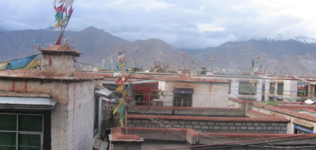
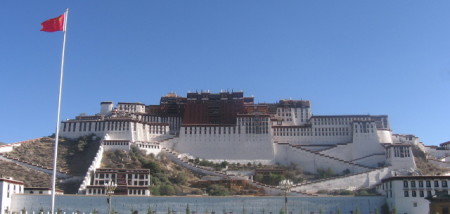
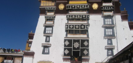
The vast majority of Tibet’s people live in rural areas, and a large but diminishing part of the population is nomadic (having no fixed residence) or semi nomadic. Lhasa, the capital and largest city, is Tibet’s principal center of trade, tourism, commerce, education, and government, and the headquarters of the region’s major religious institutions. Xigazê (Shigatse), the second largest city, is also an important trade and commercial center and the home of the Panchen Lama, the second most important leader in Tibetan Buddhism after the Dalai Lama.
The majority of people in Tibet are ethnic Tibetans, and the largest minorities are Han Chinese, China’s majority ethnic group. According to the 1990 census, 3.7 percent of Tibet’s population was Han Chinese; however, this and other population figures are believed to be incomplete, as they do not include the much larger number of Han who have come to Tibet looking for work opportunities and have not officially registered as residents. The large number of Han has exacerbated already tense relations between Tibetans and China’s central government over governmental policies in Tibet. There are also smaller populations of ethnic Lhoba, Moinba, Deng, Xiaerba, and Hui (Chinese Muslims).
Climate:
Tibet has a dry, cold climate with an average annual temperature of 1° C (34° F). Temperatures in the mountains and plateaus are especially cold, and strong winds are common year round. The river valleys experience a more moderate climate. Lhasa and central Tibet have an average temperature of 0° C (32° F) in December and an average of 17° C (60° F) in June. The daily temperature range is great. On a typical summer day, the temperature can rise from 3° C (37° F) before sunrise to 27° C (81° F) by midday . In general, temperatures in Tibet frequently drop suddenly after sunset. The average annual precipitation is 381 mm (15 in), with the largest amount falling in the southeast.
Religion:
Tibetan Buddhism is the religion of the overwhelming majority of the population. Buddhism was introduced into Tibet from India, originally in the 7th century, and then, after a period of persecution, it was reintroduced in the 11th century. Tibetan Buddhism evolved into four sects: the Nyingma, which bases its teachings on translations of the earliest works from the 7th century; the Kagyu, which was founded during the 10th and 11th centuries; the Sakya, which was founded during the 11th century and led by Tibet’s principal political rulers before the Dalai Lamas; and the Gelugpa, which originated in the late 14th century and became the largest of the four. The Dalai and Panchen Lamas belong to the Gelugpa sect.
Historically, religion permeated every aspect of Tibetan life. The only educational system was religious, all cultural and intellectual activities were centered on religious beliefs, and the heads of government were Buddhist monks. However, from 1966 to 1972, during the Cultural Revolution, religious practice in Tibet was completely curtailed. Bands of Red Guards, youths loyal to Chinese leader Mao Zedong, destroyed temples and other religious structures in Tibet, and persecuted monks and nuns.
Today, Buddhism is practiced widely in Tibet. Many monasteries and other religious buildings have been rebuilt, and monks and nuns are once again openly practicing their religion. Tibetan Buddhists are expected to recite prayers and mantras regularly, prostrate themselves at religious shrines, make offerings to temples and monasteries, and participate in various other religious rituals. Tibetans also enjoy a number of religious and cultural festivals, including Lohar, the Tibetan New Year; Monlam, which celebrates the victory of Buddha over his opponents; Sakadawa, which celebrates the anniversary of the birth, death, and enlightenment of the Buddha; and the Butter Lamp Festival, which commemorates the death of Tsong Khapa, the founder of the Gelugpa sect of Tibetan Buddhism. However, the Chinese government still enforces various restrictions, which many Tibetans deeply resent. These include a limitation on the number of clergy and the number of religious buildings. Moreover, police agents are assigned to the monasteries to prevent political activities. At times, the government also outlaws the public display of the Dalai Lama’s picture.