

Begin the trek from the historic centre of Gorkha after a 6-7 hrs drive from Kathmandu. The trail heads up the valley of the Buri Gandaki River through wild and unexplored country inhabited mainly by members of the Gurung ethnic group.
The trail circumvents interesting Manaslu peak [26915ft/8156m.] crossing Larkya pass at 5100 meter and finally emerges onto the Marshyangdi river valley along the main trail of Annapurna circuit. You will have two options as where to conclude your trek.
Trek further to Jomsom at Kali Gandaki river valley crossing which is another high and arduous hike through Thorung La Pass at 17873 fit/5416 meter and conclude the trek by flying down to Kathmandu via Pokhara, or you can also avoid a flight by walking down to Pokhara from Jomsom following the Annapurna trail in 4-5 Days. Along the way you will be rewarded with magnificent views of the Annapurna Massifs and Dhaulagiri peaks.
- Itinerary Overview
- Detailed Travel Plan
- Included / Excluded
- Travel Notes
- Departure Dates
- Day 1 : Arrive Kathmandu.
- Day 2 : Sightseeing tour.
- Day 3 : Drive to Arughat Bazaar [1749ft/530m].
- Day 4 : Trek to Sundi Khola [3300ft/1000m].
- Day 5 : Trek to Machha Khola [4290ft/1300m].
- Day 6 : Trek to Jagat [4488ft/1360m].
- Day 7 : Trek to Deng [5940ft/1800m].
- Day 8 : Trek to Ghap [6930ft/2100m].
- Day 9 : Trek to Lho Village [10494ft/3180m].
- Day 10 : Trek to Sama Gaon [11088ft/3360m].
- Day 11 : Rest day.
- Day 12 : Trek to Larkya Lodge (Dharamsala) [14718ft/4460m]
- Day 13 : Trek to Tanbuche [12870ft/3900m].
- Day 14 : Trek to Karche [9190ft/2785m].
- Day 15 : Trek to Bagarchap [7128ft/2160m].
- Day 16 : Trek to Chame [8679ft/2630m].
- Day 17 : Trek to Pisang [12903ft/3910m].
- Day 18 : Trek to Manang [11616ft/3520m].
- Day 19 : Trek to Thorung Phedi [14850ft/4500m].
- Day 20 : Trek to Muktinath [12540ft/3800m].
- Day 21 : Trek to Jomsom [8953ft/2713m].
- Day 22 : Fly to Pokhara
- Day 23 : Free Day
- Day 24 : Fly to Kathmandu
- Day 25 : Departure.
- Day 1 : Arrive Kathmandu.
It is a panoramic thrill flying into Kathmandu on a clear day. The views of snow-capped mountain peaks sprawling down below you are almost ecstatic, beginning a whole chain of memorable experiences that stay with you for a long, long time. A representative and driver from Explorer Nepal will meet you at the airport and escort you to Hotel. At the hotel you will be briefed about your daily activities.
Check In at the Hotel. - Day 2 : Sightseeing tour.
After breakfast at the hotel, commence the sightseeing tour of Kathmandu city, Swayambhunath and Patan city.
Kathmandu city: Kasthamandap, the source of the name Kathmandu means ‘made from the timber of a single tree’. Also known as Kantipur, the capital Kathmandu is the hub of Nepal's art and culture. It is a place for rest, relaxation and easy-day sightseeing of historic and artistic temples and monuments. Kathmandu Durbar Square with its arrays of temples, Seto Machhindranath and the ancient palace of the former Nepali Royals enriches your experience of the centuries old civilization.
Swayambhunath Stupa: Said to be around 2000 years old, this Buddhist Stupa sits atop a hill. The main stupa is composed of a solid hemisphere of brick and earth supporting a lofty conical spire crowned by a pinnacle of Copper gilt. Painted on the four sided base of the spire are the all seeing eyes of Lord Buddha. The hill of Swayambhunath is a mosaic of small Chaityas and Pagoda temples. You’ll get a scenic view of Kathmandu city from there.
Patan city: Located about 5 km south of Kathmandu, Patan is one of 3 royal cities in the valley. A destination for connoisseurs of fine arts, Patan is filled with wood and stone carvings, metal statues, ornate architecture, including dozens of Buddhist and Hindu temples, and over 1200 monuments.
Patan is believed to have been built in the third century B.C. by the Kirat dynasty later expanded and enriched by the Licchavi and the Malla rulers in the medieval period. Patan Durbar Square, like its counterpart in Kathmandu, is an enchanting mélange of palace buildings, artistic courtyards and graceful pagoda temples. The former Royal palace complex is the centre of Patan’s religious and social life, and houses a beautiful museum. One remarkable monument here is 16th century temples dedicated to the Hindu go Krishna, built entirely of stone.
Check In at the Hotel. - Day 3 : Drive to Arughat Bazaar [1749ft/530m].
We drive along the Kathmandu-Pokhara Highway for the first part of the day; we then head towards the hill bazaar of Gorkha. The road gets a bit rough after Gorkha. We will reach our destination, Arughat Bazaar, after seven hours from Kathmandu.
Overnight at camp. - Day 4 : Trek to Sundi Khola [3300ft/1000m].
On our first day on the trail we head north, following the Buri Gandaki. In the low country rice paddies and picturesque hamlets surround us. After climbing briefly to Kyoropani, we descend once again to the river and at the confluence with the tributary of Sundi Khola. It is a nice first day not too long, and perhaps we have time for a refreshing swim sometime during the day for it is hot in the low country.
Overnight at camp. - Day 5 : Trek to Machha Khola [4290ft/1300m].
The country changes, the broad valley narrows and at times the trail is cut into the steep valley side, which is densely forested. We pass a number of small villages, tucked into the hillside, until we reach a widening of the valley, opposite the point where a large tributary stream enters the Buri Gandaki. The terraced farmland here belongs to the village of Lapbesi. We descend once again to the wide, sandy riverbed and follow a path, which runs below the steep, craggy valley side. At length, we have to climb up once again on a trail to Machha Khola, which has a number of teashops.
Overnight at camp. - Day 6 : Trek to Jagat [4488ft/1360m].
We cross the Machha Khola - Fish Stream - and head upstream to the tiny village of Khola Bensi and the hot springs at Tatopani. The valley sides remain steep until they are impassable and the route then switches to the left bank by way of a suspension bridge. The trail is quite exposed and challenging in places. After a short section of forest path we reach the single teahouse at Doban. Above Doban, the Buri Gandaki descends an impressive series of rapids. Beyond this steep section, the river is much more placid, meandering across a broad gravel bed. At Lauri, we will cross the river on a suspension bridge, and then climb on a high path to the fields of Jagat.
Overnight at camp. - Day 7 : Trek to Deng [5940ft/1800m].
After descending a long series of stone steps to the river, we climb a terraced hill to Saguleri, from where we can see the impressive Sringi Himal (7187m). The path splits, with the right-hand branch heading off towards the Ganesh Himal while crossing the river at Gata Khola. Our route continues upstream, through a gorge with towering walls. We cross the river thrice in the next two hours to avoid difficult valley sides and then climb up over a further steep spur to reach the village of Deng.
Overnight at camp. - Day 8 : Trek to Ghap [6930ft/2100m].
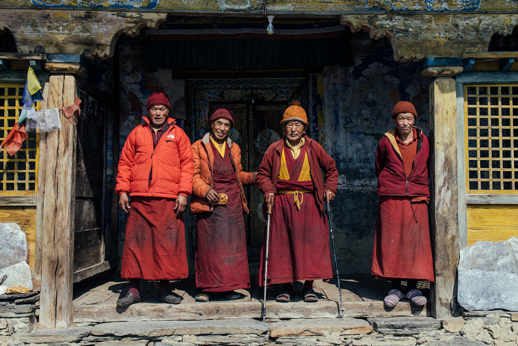
The valley is still steep-sided and most impressive. We cross the village of Lama, and start to see mani stones (prayers etched onto wayside rocks), a sure sign that we are entering a high country Buddhist region. After only about four hours we reach the village of Ghap, which straddles the river. We have entered the Tibetan area. There's a perceptible change in the climate and culture. It gets pleasantly cool, as we start to gain the altitude.
Overnight at camp. - Day 9 : Trek to Lho Village [10494ft/3180m].
The higher altitude takes us into alpine territory and increasing mountain views. There are more Mani walls and 3 more crossing of the Buri Gandaki on our route to Namrung, where our special permit is checked. Above this village the valley opens out and there are extensive pastures. Climbing gently now, and crossing a large stream flowing down from the Lidanda Glaciers, we reach the Tibetan village of Sho, 3000m. We will get our first incredible views of the Manaslu North and then of Manaslu main ahead from Sho. As we continue we come to Lho, a large village at 3150 metres where there is a lovely little monastery and numerous chortens and Manis. Looking back Ganesh I is visible.
Overnight at camp. - Day 10 : Trek to Sama Gaon [11088ft/3360m].
Leaving the village, we follow the right bank of the river, with views of Peak 29 ahead. As we continue on the main trail, we soon reach the fields of Sama Gaon, 3500m. We reach Sama Gompa, 20 minutes beyond the village and Samdo, near the Tibetan border.
Overnight at camp. - Day 11 : Rest day.
Surrounded by mountains in a peaceful forest, today we take a rest to acclimatize and relax. It is a good time to catch up on that book or wash clothes.
Overnight at camp.
- Day 12 : Trek to Larkya Lodge (Dharamsala) [14718ft/4460m]
The thundering Buri Gandaki trickles to a stream as we continue to follow its course ever upwards. We are surrounded by spectacular mountains from all sides. Manaslu is particularly impressive. After crossing to the east bank of the river, we reach the last permanent settlement in the valley, which is called Sumdu. Above the village we cross the stream, which runs down from the Gya La (Pass), the pass to Tibet. We come to the ruins of an abandoned village, known as Larkya Bazaar. Presumably this village thrived as a trading point, with Tibet lying over the Gya La. The commerce seems to have dried up leading to the migration of the settlers. Nearing the Larkya Glacier, we reach a lodge at 4450m, which has been built to serve the travelers crossing the Larkya La.
Overnight at camp. - Day 13 : Trek to Tanbuche [12870ft/3900m].
After a short climb above the lodge, we reach the ablation valley on the north side of the Larkya Glaciers. There are views of Cho Danda and Larkya Peak. We walk across the moraines of the glacier, making a gradual ascent, which becomes steeper only in the last section of the pass. From the pass, there are outstanding views of Himlung Himal, Cheo Himal, Kangguru and the huge Annapurna II. Initially, there is a steep descent over snow and then scree, to reach the ablation valley trail to Larcia Kharka. A further on, a moraine ridge path leads to Tanbuche.
Overnight at camp. - Day 14 : Trek to Karche [9190ft/2785m].
Below us is Bimthang, a broad and level ablated valley with a number of Mani walls and deserted houses. Crossing this high pasture, we descend the valley of the Burdin Khola to the area of the Base Camp for the west side of Manaslu. From a ridge at 4150 metres, we have excellent views of Manaslu to the south-east and Annapurna II to the south-west. Beyond a bridge over the headwaters of the Dudh Khola, we descend into rhododendron forests and follow a trail through a narrow valley until we reach the highest cultivated land in this valley at Karche.
Overnight at camp. - Day 15 : Trek to Bagarchap [7128ft/2160m].
We climb through terraced fields to the Karche La pass, and can see ahead a green and heavily forested valley, dropping down to the distant Marshyangdi river. At Thonje village is our final restricted area check post. Here we cross the Marshyangdi river and join the main Annapurna Circuit, and the hoards of trekkers. We arrive at Bagarchhap, a Bhotia village with prayer flags fluttering in the breeze.
Overnight at camp. - Day 16 : Trek to Chame [8679ft/2630m].
Today we continue to climb through forests of pine and oak. We pass through Dhanakyu before coming to a thundering waterfall. Further on, the Marshyangdi Khola enters a gorge and the path consists of steep stone steps. Pausing for breath, we can look back at the views of Manaslu. When the steep incline ends we follow a path amid magnificent rhododendrons to Ratamron and then continue on a gently rising path, crossing a stream before entering a pine forest. We then cut across a loose hillside to the hamlet of Kotho from where we can look straight up at nearby Annapurna II - a sight convincing us that we are deep in the Himalayan mountains. From here the trail climbs through a fir and pine forest to Chame. Chame is the administrative headquarter of the Manang district. There are government offices, shops, and hotels. This is only a half day trek.
Overnight at camp. - Day 17 : Trek to Pisang [12903ft/3910m].
With Lamjung Himal [22746ft/6893m] sparkling in the morning sun, we set off for Pisang. The mountain disappears as we climb the path up the valley, passing a huge apple orchard. We continue through a fir and pine forest, climbing to a high, rocky area, as the opposite bank becomes an impassable cliff. From this point the valley becomes extremely steep-sided as we follow the path to Bratang. In the past, this was the military station for troops who fought against the Khampa tribal revolutionaries. The dilapidated buildings are the only remainders of that era. A short climb from the village brings us to a rock-strewn area where we cross a wooden bridge and follow a high, winding path, before crossing back to the right bank again. We now walk through a pine forest and as the forest ends, the valley changes from a V-shape to a gentle U-shape, opening up a wonderful vista before us. We can see the east peak of Annapurna II as well as Pisang Peak to the north-east. Trudging along, we come to a long mani stone wall by a bridge and the lower village of Pisang.
Overnight at camp. - Day 18 : Trek to Manang [11616ft/3520m].
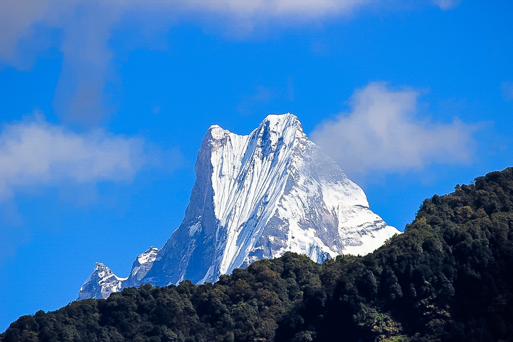
Beyond Pisang, the trail climbs a steep ridge, which affords good views of the Manang valley and Tilicho peak. Descending past Manang's airstrip at Hongde, we come to a level area from where the north-east face of Annapurna III rises majestically above us. From the wide plains of the Sabje Khola Valley, Annapurna IV [24832ft7525m] also becomes visible. Just beyond this point, we cross the Marshyangdi Khola via a wooden bridge to the tiny village of Mungji. Cultivated fields appear on both sides of the path. Off to the right, below a craggy mountain, we can see the village of Bryaga with its splendid monastery. Large chortens and mani walls abound and the tall peaks of the Himalayas spread out before us - Annapurna II, Annapurna III, Annapurna IV, Gangapurna [24601ft/7455m] and, to the rear, Tilicho Peak [23542ft/7134m].After a short steep climb we reach Manang, which is a surprisingly large village for this remote mountain pocket.
Overnight at camp. - Day 19 : Trek to Thorung Phedi [14850ft/4500m].
From Manang, we climb to the next village of Tengi, with the magnificent Annapurna Himal in view, while behind us we can see Peak 29 and Himalchuli from the distance. We are now past the tree line and the vegetation consists of alpine grasses and scrub juniper. Climbing the path, past the summer village of Gunsang, we cross the Gundon Khola via a wooden bridge. From here we can see ahead the mountains surrounding the Thorung La, which we are going to cross tomorrow. The trail goes up and down. As the elevation gradually increases, we soon enter an alluvial delta where there are yak pastures. An hour beyond this, we come to the small settlement of Letdar. Leaving Letdar, we climb gradually to a ridge before descending to the headwaters of the Marshyangdi and crossing a wooden bridge. After a short ascent up the mountain path on the right bank, we follow a narrow trail across an unstable screed slope and then descend to Thorung Phedi.
- Day 20 : Trek to Muktinath [12540ft/3800m].
We will start our journey a little early today to cross the Thorung La [17873ft/5416m]. The trail is steep but well-trodden, as this trail has been used by local people for hundreds of years. As we continue, the gradient eases and after around 4 hours of steady climbing we reach the chorten and prayer flags of the pass. The views are dramatic: from the snow covered mountains above, to the head of the Kali Gandaki valley below and the brown and purple hills of Mustang which spreads out before us. The descent to Muktinath is a tiring 5280ft/1600m descent but it's compensated for with excellent views of Dhaulagiri. Eventually the moraines give way to grassy slopes before a pleasant walk along the Jhong Khola Valley to Muktinath, with its shrines and temple.
Overnight at camp. - Day 21 : Trek to Jomsom [8953ft/2713m].
We now begin the descent down the dramatic Kali Gandaki valley through an arid region which lies in the same geographical and climatic zone as Tibet. After passing through Jharkot and Khingar, villages with typical Tibetan architecture, we follow the valley floor most of the way to Jomsom and are rewarded with tremendous views of both Dhaulagiri and Nilgiri. Jomsom is a large town sprawled along both the banks of the Kali Gandaki River.
Overnight at camp. - Day 22 : Fly to Pokhara
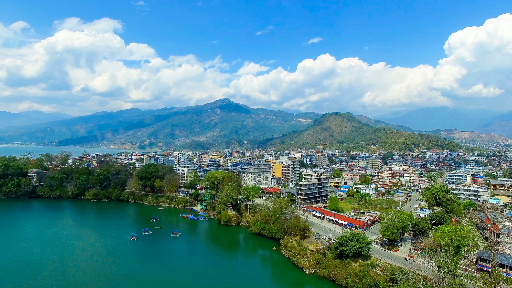
We take an early morning flight to Pokhara. It is a spectacular flight along the Kali Gandaki gorge and provides wonderful views of the Dhaulagiri and Annapurna ranges.
Overnight at Hotel. - Day 23 : Free Day
This day is leisure and you can enjoy Pokhara city, this day extra if incase there is no flight from Jomsom to Pokhara. You can enjoy Trekker's Massage, Paragliding, or boating at Phewa Lake.
- Day 24 : Fly to Kathmandu
In the afternoon after breakfast at the hotel, our team will assist you to the airport and arriving in Kathmandu will assist you to hotel. Later Diner at Cultural Restaurant.
- Day 25 : Departure.
Our Nepalese support team will take you to the airport for your flight home.
-
Included
- Meet, assisted upon arrival at Kathmandu by our office representative.
- All arrival / Departure transfers as per the itinerary by air-conditioned vehicle.
- 03 Nights twin/double room accommodation with breakfast at 3 star hotel in Kathmandu.
- Fully organize camping trek including all meals (breakfast, lunch and dinner) with Tea and coffee and hot water including guide and necessary support staffs with their insurance and salaries.
- Kathmandu city tour as per the above itinerary with our local English speaking guide including monumental entrance fees.
- Airfare for the sector Jomsom / Pokhara / Kathmandu with domestic airport tax and necessary airport transfers.
- Annapurna Conservation Area Permit and Trekkers’ Information Management System fee.
- Surface transfers Kathmandu / Arughat Bazaar with necessary vehicle retention.
- First Aid Medical Kit box.
- Applicable hotel taxes presently 24.3%
-
Excluded
- Any meals in Kathmandu other than breakfast.
- Travel insurance.
- International air fare to and from Nepal.
- Nepal Tourist Visa fees.
- Items and expenses of personal nature.
- Any kind of alcoholic drinks, cold drinks, snacks, laundry, phone call, internet.
- Personal Trekking Equipments.
- Emergency Evacuation (Helicopter Rescue).
- Any costs which arise due to a change of the itinerary, landslides, domestic flight delays due to weather, political disturbance and strikes etc.
- Any other costs whatsoever, that is not mentioned in the cost inclusion.
- Horse renting and additional porters during the trek.
- Tipping amount.
It is one of the moderate types trekking, because you are going above the 4156 meters at high. That’s why before you decide to do this trek you have to do some training. You will be walking 5 to 8 hrs a day; you need to have very good shoes. As you are going every day 500 to 1000 meters of altitude, you have to drinks lots of Water. During your trek you might get altitude sickness. Please read the symptoms of altitude sickness. If you have symptoms of ATS please tell our guide, so that he can take care of you.
Trip Duration:
25 Days
List of things you need to bring:
Dawn Jacket-1, Wind Proof-1, Gore-Tex-1, T-Shirt-4/6, Socks-4/6, Hat-1, Woolen Hat-1, Gloves-1pair, Trekking Boot-1Pair, Hiking shoe or Plipflop-1Pair, Raincoat-1, Water Bottle(1/2ltrs), Sunglass-1, Sun lotion, Towel, Thormel Trouser-2 pairs, Pool over-1, Sleeping Bag-1.
Best Months to do this trek:
Feb/March/April/June/Sep/Oct/Nov, July and August Okay.
Rhododendron:
Middle of March - April.
| Departure Date | Avaibility | Price | Note | Book Trip |
|---|---|---|---|---|
|
No Departure Dates Found.
|
||||


